 We’re currently working on a masterplan for an unusual, yet very interesting, project type— an oyster hatchery.
The site is a long, narrow piece of land sloping down from Quinnipiac Avenue to the edge of the Quinnipiac River in Fair Haven. This particular neighborhood of New Haven has been listed with the National Register of Historic Places since the early 1980’s, and was originally developed by the oyster fishing industry in the 1800’s. We’re particularly excited to re-introduce this activity to the area in a 21st century manner.
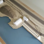
It was extremely important to us to help our clients and the neighboring property owners visualize the new site development and understand what’s being proposed. We built a physical model of the site, which leveraged our digital building and site models. The sloped land surface is made of a cardstock sheet, cut into sections on a laser cutter. Construction paper glued down over the contours show roadways, sidewalks, and water. The buildings were made using our 3D printer. “Kinetic sand” was used to simulate the large oyster pile. The model was finished up by a plexiglass cover for the water and a maple wood frame.
Site Contours
Site contours are made of cardstock, laser cut from large sheets per our surveyor’s drawing, at 2-foot increments. We created the outlines by exporting our Revit site model into AutoCAD, isolating the topo contours, then bundling the various contours to be as efficient as possible with the cardstock sheets.
3D Printing Building Massings
The existing and new buildings are built virtually in three dimensions using Revit. This information is then simplified, exported and built in our Makerbot 3D printer. The process enables us to design and refine the new buildings- we can quickly experiment with different ideas for dormers, sheds, roof lines, and overall proportions.
Putting it all together
The water layer plus cardstock contours are gently glued together onto a plywood base. The paper roads and walkways get added in. Once all these pieces are put together, a maple frame finishes the edges and helps keep everything in place. Plastic models representing the existing-to-remain buildings are glued down to the contours, while the new buildings are left loose, so we can easily modify and refine the design of these as the project moves forward. Rather than being a one-off snapshot in time, this model is really intended to be a living tool that will change and update as the design progresses.
Model making, once an integral part of architectural design practice, has sadly been on the decline lately. We’re making a point to use it- not just for presentations but for iterative design development and improvement. It’s also fun! We had a great time coming up with the best material for each component, and putting it all together. Best of all- the model, combined with supplemental diagrams and renderings, really showcases how all of the elements work together to create the oyster hatchery.


